綠色和平
相信大家可能有讀過綠色和平為教研中心撰寫得博客文章《氣候危機將令香港沿海地區受到更嚴重的風暴潮威脅》,以下最新的文章由綠色和平專項地理信息系統GIS的研究員,為大家簡單解釋風暴潮影響地區互動地圖是怎麼製作的。
互動地圖讓你了解氣候變化下風暴潮對香港的威脅
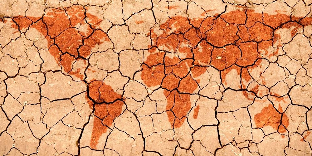
全球暖化是不爭的事實,數十年後對我的生活有多大影響呢?隨著氣候危機惡化,本港的海平面將進一步上升。綠色和平評估,到本世紀中,山竹級的風暴潮最高水位恐成十年一遇,屆時香港受海水入侵範圍達28平方公里,相等於147個維園,影響近十萬人。那裡會是受威脅的地區?你住的地方又是否安全呢?
認清香港的氣候危機
氣候變化像是一個老生常談的危機,澳洲山火、冰川融化等都令人觸目驚心。但危機是否遠在天邊,與香港無關呢?冰川融化,導致海平面升高。香港作為沿岸城市,無可避免將受到衝擊。根據香港天文台資料[1],受氣候危機導致的海平面上升影響,到本世紀中維港十年一遇風暴潮最高水位將接近4米,與山竹時的紀錄相若[2]。而山竹襲港期間,維港的最高水位是5個潮汐站當中最低的,意味那些海拔不高於4米的地區可能更頻密地面對受到極端高的風暴潮威脅。
You are here
Publications & Research
Publications & Research
We provide a platform between researchers, disaster practitioners, healthcare professionals and students for expertise exchange, collaboration and policy discussion.

Publications & Research
The HKJCDPRI Publications Section contains collaborative researches and publications with our partners and renowned academic institutions, and other research and development projects related to disaster preparedness and response.
The Guidelines section contains our selected collection of technical information, operational guidelines and useful tools for disaster management.
The Blog sub-section provides a platform where our team and peers share news and updates, as well as opinions and experiences in building disaster preparedness for the communities.
The blog posts are written by the author in his own personal capacity / affiliation stated. The views, thoughts and opinions expressed in the post belong solely to the author and does not necessarily represent those of Hong Kong Jockey Club Disaster Preparedness and Response Institute.
All resources listed here are freely and publicly available, unless specified otherwise. We ask users to use them with respect and credit the authors as appropriate.
2020
25/08/2020
[This article is only available in Chinese.]
[This article is only available in Chinese.]
綠色和平
相信大家可能有讀過綠色和平為教研中心撰寫得博客文章《氣候危機將令香港沿海地區受到更嚴重的風暴潮威脅》,以下最新的文章由綠色和平專項地理信息系統GIS的研究員,為大家簡單解釋風暴潮影響地區互動地圖是怎麼製作的。
互動地圖讓你了解氣候變化下風暴潮對香港的威脅
全球暖化是不爭的事實,數十年後對我的生活有多大影響呢?隨著氣候危機惡化,本港的海平面將進一步上升。綠色和平評估,到本世紀中,山竹級的風暴潮最高水位恐成十年一遇,屆時香港受海水入侵範圍達28平方公里,相等於147個維園,影響近十萬人。那裡會是受威脅的地區?你住的地方又是否安全呢?
認清香港的氣候危機
氣候變化像是一個老生常談的危機,澳洲山火、冰川融化等都令人觸目驚心。但危機是否遠在天邊,與香港無關呢?冰川融化,導致海平面升高。香港作為沿岸城市,無可避免將受到衝擊。根據香港天文台資料[1],受氣候危機導致的海平面上升影響,到本世紀中維港十年一遇風暴潮最高水位將接近4米,與山竹時的紀錄相若[2]。而山竹襲港期間,維港的最高水位是5個潮汐站當中最低的,意味那些海拔不高於4米的地區可能更頻密地面對受到極端高的風暴潮威脅。
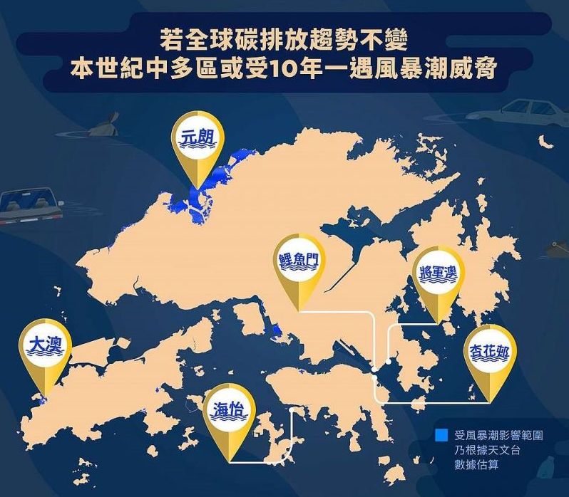
這些地區在那裡,有多少面積和人口將會受到威脅?我們整合了氣象、地理等科學數據,製作以下的互動地圖,顯示香港容易受極端風暴潮影響的地區、面積和人口,幫助政府和市民瞭解相關資訊,盡早採取氣候行動,以減少氣候變化所帶來的人命傷亡和財物損失。
【看地圖】查閱香港容易受極端風暴潮影響的地區、面積和人口
地圖上藍色陰影的地方,表示這些沿海地區的海拔高度不高於4米,到世紀中可能平均每十年被類似山竹的風暴潮侵襲。
互動地圖網頁版:https://arcg.is/1qKbmO
查看這地圖很簡單:
1.可以在地圖左上角,按加、減縮放地圖,查看整個香港或者某個地區的情況。
2.如果你想知道某個地點將來會否受風暴潮侵襲,可以利用網頁右上方的搜尋框,輸入地點名稱,例如大澳,地圖就會轉換到搜索的地點。

3.不妨搜尋自己和家人朋友的住址,看看將來大家會否面對風暴潮淹浸(有藍色陰影)的危險。
4.我們還對18區受影響的面積和人口進行了統計,大家可以點擊地圖上的區域,例如元朗,地圖會彈出資訊顯示這區受影響的人口接近4萬人,受影響的面積接近17平方公里。

大家可以找找看,那些區受影響的面積比較大?那一區受影響最大?這些區受影響的人口分別是多少?那一區受影響人口最多?
居安思危,香港在極端風暴潮下的影響
綠色和平發現,到本世紀中類似山竹引起的風暴潮,海水入侵範圍達28平方公里,涉及近10萬人。其中香港西北面將成為重災區,元朗和北區共佔受威脅總面積接近71%(約20平方公里),約6萬人面對風險。
而繼元朗和北區後最多人受威脅的3區,是荃灣區麗城花園至海濱花園一帶的海旁,南區則有鴨脷洲沿海地區及香港仔海濱等,以及中西區堅尼地城新海旁一帶的民居,影響介乎6000至1.1萬人。一些沿海建設,如葵涌貨櫃碼頭、港澳碼頭、中環碼頭等,亦面對海水入侵及運作受阻的風險。

圖三: 根據天文台數據估算,受風暴潮影響的範圍
按評估在極端風暴潮影響下,還有許多香港人和遊客喜歡去度假的大澳、貝澳和梅窩也難逃威脅。大澳過去已經有多次受到颱風造成的淹浸或海水倒灌,根據天文台記錄[3],2008年颱風黑格比帶來的風暴潮造成部分地區水深升至一層樓的高度,水浸引致電力中斷,在漆黑環境下,多人被困屋內,有居民從二樓窗口跳下游泳離開,當中大澳就是重災區之一。

圖四:經歷過往的颱風襲港慘痛經驗,2018年大澳居民在超級颱風山竹來襲之前,嚴陣以待。(來源:綠色和平)
2018年的山竹影響的地區更多,根據天文台的紀錄[4],除了大澳之外,還有石壁、梅窩、長洲、杏花邨、小西灣、海怡半島、鯉魚門、將軍澳、沙田、大埔、西貢、元朗、流浮山、沙頭角、石澳及坪洲等多處沿岸地區因風暴潮和大浪而嚴重水浸。
多個沿岸設施包括污水處理廠、公眾泳灘、海濱長廊及運動場都受到不同程度的損毀。海水亦湧入杏花邨及將軍澳南一帶,有地下停車場被海水淹浸,多輛汽車被淹沒。沙田城門河、吐露港沿岸及大埔林村河一帶的單車徑及行人隧道亦被海水淹浸。西貢南圍、流浮山、大埔三門仔新村、沙頭角新村亦有多間村屋水浸。在巨浪下數以百計不同大小的船隻擱淺、沉沒或受嚴重破壞。各區的農田、魚排及魚塘均有不同程度的損毀。

圖五:2018年超級颱風山竹,杏花村災情記錄。(來源:綠色和平)
到世紀中,氣候危機導致極端天氣,如超級颱風發生的機會愈來愈多,這些海拔比較低的地方會更加頻繁的受到海水淹浸,可能帶來巨大財產,甚至生命的損失。政府和市民需要提前做好相應的準備,把損失減至最低。
地圖當中的科學
這地圖能否幫助大家更深刻地體驗海平面上升帶來的影響?
我們主要是用香港陸地的海拔高度資料製作互動地圖,而資料是來自地政總署製作的數碼地形模型(DTM)[5]。然後,我們在GIS專業軟件中進行處理,設置把海邊不高於4米的地方[6]挑選出來,然後把這些不高於4米的地區根據18區的邊界進行匯總統計,計算每個區內的面積和人口[7]總數。最後,再將這些資料檔案上傳到專業線上地圖網站。
備註:
[1] 香港天文台《Sea-level Rise and Storm Surge – Impacts of Climate Change on Hong Kong》
[2] 香港天文台《什麽是風暴潮?》
[3] 香港天文台《颱風黑格比在香港引起的風暴潮個案研究》報告
[4] 香港天文台《超強颱風山竹(1822)》報告
[5] 香港地政總署數碼地形模型(DTM)
[6] 內陸不高於4米的地方未有包括,因考慮到地點與海岸有距離,海浪即使高於4米,影響也會減退。
[7] 人口資料來自哥倫比亞大學社會經濟資料與應用中心發佈的2020年世界人口分佈資料,該資料以1公里網格格式呈現人口數量。
作者:綠色和平
原文轉載:氣候危機殺到!到世紀中你家還安全嗎?

19/08/2020
[This article is only available in Chinese.]
[This article is only available in Chinese.]
最近醫學界傳出新冠狀病毒 (COVID-19) 變種,由原來的D614變為G614,令大家都很擔心,究竟詳情是怎樣呢?擔心新冠狀病毒由原來的D614變為G614,其實是擔心它的傳染性、病情嚴重性和對研發疫苗有什麼影響。
最近醫學界傳出新冠狀病毒 (COVID-19) 變種,由原來的D614變為G614,令大家都很擔心,究竟詳情是怎樣呢?擔心新冠狀病毒由原來的D614變為G614,其實是擔心它的傳染性、病情嚴重性和對研發疫苗有什麼影響。
18/08/2020
On 4 August 2020, there was a big chemical explosion in Beirut causing at least 159 death, 6,000 injuries and 300,000 homeless as estimated on 10 August 2020. The explosion was caused by 2,750 tons of ammonium nitrate. The damage was equivalent to 3.3 magnitude of earthquake.
The estimated global production of ammonium nitrate is about 21.6 million tons in 2017. It is predominantly used in agriculture as a high nitrogen fertilizer. As ammonium nitrate is relatively very stable, it is mainly used as explosive mixtures in mining, quarrying, and civil construction. Similar formulations have been used in improvised explosive devices (IED) by terrorists.
Ammonium nitrate is a white crystalline solid with the chemical formula NH4NO3. Ammonium nitrate is stable at ambient temperature and pressure However, it may detonate from a strong initiation charge. Therefore it should not be stored near high explosives or blasting or combustible agents.
Although ammonium nitrate is relatively stable at room temperature, solid ammonium nitrate will decompose when heated. At temperatures around 300 °C, it will decompose into nitrous oxide (N2O) and water (H2O):
NH4NO3 → N2O + 2H2O
At high temperature above 300 °C, the following reaction predominates.
2NH4NO3 → 2N2 + O2 + 4H2O
It is important to note that both reactions are exothermic (release heat) and their products are mainly gases, especially oxygen. According to the media report, the fire and smoke were first caused by welding carried out by workers (Figure 1). Exothermic reaction will generate heat that produces more oxygen, which supports combustion and thus leads to a violent explosion. The appearance of red–orange colour explosion cloud (Figure 2) is caused by the existence of a secondary reaction product, nitrogen dioxide (NO2). Large stockpiles of the material can also cause a major fire and risk of explosion due to supporting oxidation which can be easily escalated to detonation. Various types of gaseous such as nitrogen, nitrous oxide, nitrogen dioxide, hydrogen cyanide and steam can be produced in detonation, leading to the formation of a big mushroom-cloud (Figure 3).
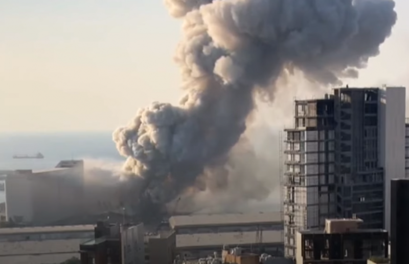
Figure 1: Welding sparkled fire and smoke
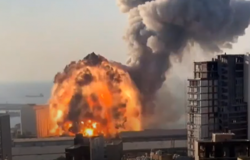
Figure 2: Orange color Nitrogen Dioxide explosion cloud
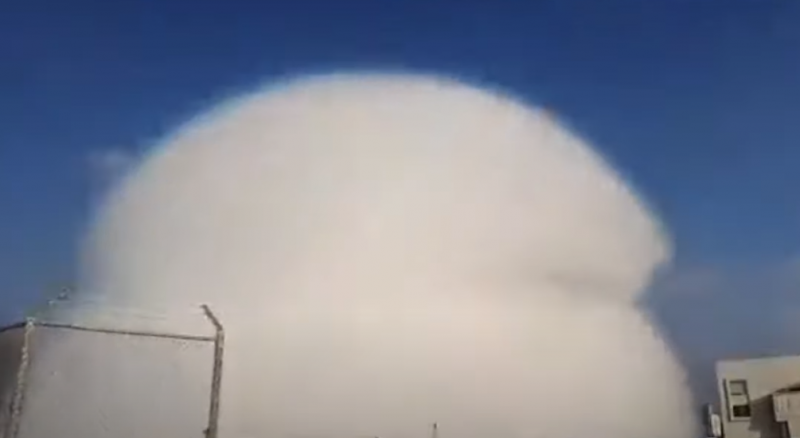
Figure 3: Large Mushroom cloud
The greatest detrimental effect is that explosion can cause primary blast injury. The powerful high energy wave travels at high speed. In addition to the physical injuries such as burn, fracture and wound, the blast wave will cause a sudden expansion and contraction to rupture air-filled body organs that contain gas such as lung, gut and the eardrum. Moreover, the blast wave will force air to penetrate into the blood vessel, causing the fatal gas embolism (air bubble inside blood vessel). The energy release in explosion is inversely proportional to the cube of the distance from the explosion source. The farther one stays away, the lesser the damage is.
The major challenge to the medical team will be safety as multiple explosions may happen. Moreover, toxic chemical hazard is another threat. The station of the medical team should be located at safe distance from the explosion site. Usually hot, warm and cold zones would be established according to the advice from the safety experts at the scene. If the medical team is not trained to don and doff appropriate personal protective equipment (PPE), they should only work in cold zone which is free from chemical hazards.
Ammonium nitrate is not hazardous to health and is usually used in fertilizer products. However, after burning or explosion, various types of toxic gaseous will be produced. Nitrogen dioxide (NO2), the orange explosion cloud, will usually be produced after chemical explosion of ammonium nitrate. Although NO2 is a well-known air-pollutant in our daily life from chemical factories, at high concentration of NO2 after explosion, it has corrosive property and will cause irritation to the airway and lung, producing bronchitis and pulmonary edema.
Chronic exposure to NO2 can cause respiratory effects including airway inflammation of healthy people and increased respiratory symptoms in people with asthma or chronic obstructive airway diseases. NO2 will be infinitely diluted in the atmosphere if there is no continuous gas production.
Dr. Jimmy Chan,
President of HK Association for Conflict and Catastrophe Medicine.
FHKAM(Surgery), FHKAM (Emergency Medicine)
Regional Director (HK), Advanced HazMat Life Support International, USA.
References:
1. Martel, B.; Cassidy, K. (2004). Chemical Risk Analysis: A Practical Handbook. Butterworth–Heinemann. p. 362. ISBN 1-903996-65-1.
2. Karl-Heinz Zapp "Ammonium Compounds" in Ullmann's Encyclopedia of Industrial Chemistry 2012, Wiley-VCH, Weinheim. doi:10.1002/14356007.a02_243
3. Ammonium nitrate sold by ton as U.S. regulation is stymied.Archived 28 February 2018 at the Wayback Machine – The Dallas Morning News
4. "The chemistry behind the Beirut explosion".
5. "Nutrient Content of Fertilizer Materials" (PDF). Archived from the original (PDF) on 24 December 2012. Retrieved 27 June2012.
6. Cook, Melvin A. (1974). The Science of Industrial Explosives. IRECO Chemicals. p. 1. ASIN B0000EGDJT.
7. Brook, Tom Vanden. "Afghan bomb makers shifting to new explosives for IEDs". USA TODAY.
8. Chemical Advisory: Safe Storage, Handling, and Management of Ammonium Nitrate United States Environmental Protection Agency
9. "Storing and handling ammonium nitrate" (PDF). Archived(PDF) from the original on 4 July 2011. Retrieved 22 March 2006.
10. Pradyot Patnaik (2002). Handbook of Inorganic Chemicals. McGraw-Hill. ISBN 0-07-049439-8.
11. "Ammonium nitrate". PubChem. Retrieved 6 August 2020.
12. "Ammonium Nitrate". webwiser.nlm.nih.gov. Retrieved 6 August2020.
13. Fertilizers Europe (2006). "Guidance for Compatibility of Fertilizer Blending Materials" (PDF).
14. Ammonium Nitrate-Regulating its use, Balancing Access & Protection from "Worksafe Victoria". Archived from the originalon 11 March 2011.
15. "Chemicalland21 – Ammonium Nitrate". Archived from the original on 10 January 2012.
16. "Material Safety Data Sheet, Ammonium nitrate MSDS".
17. Chaturvedi, Shalini; Dave, Pragnesh N. (January 2013). "Review on Thermal Decomposition of Ammonium Nitrate". Journal of Energetic Materials. 31 (1): 1–26. doi:10.1080/07370652.2011.573523.
18. "Lebanon's president calls for two-week state of emergency in Beirut after blast". Beirut. Reuters. 4 August 2020. Retrieved 4 August 2020. Aoun, in remarks published on the Presidency Twitter account, said it was “unacceptable” that 2,750 tonnes of ammonium nitrate was stored in a warehouse for six years without safety measures and vowed that those responsible would face the “harshest punishments”.

18/08/2020
[This article is only available in Chinese.]
[This article is only available in Chinese.]
香港賽馬會災難防護應變教研中心
綠色和平根據天文台的數據,為香港不同地區進行估算,找出香港那些地區會最受風暴潮影響,並且製作成地圖供市民參考。到底甚麼是風暴潮呢?
根據天文台的資料[1],風暴潮是與熱帶氣旋(即大家一般理解的颱風)相關的低氣壓及大風的共同影響而導致海平面上升的現象。
熱帶氣旋的強風將海水推向岸邊, 並於沿岸地區堆高是海平面上升的主要成因(圖一)。
圖 一 強風的影響 (來源:香港天文台)
而熱帶氣旋中心的低氣壓也會增加風暴潮的高度。由於在熱帶氣旋邊緣的氣壓較高,外圍的海水會被壓低,而熱帶氣旋中心附近的海水則會被吸起(圖二)。
香港賽馬會災難防護應變教研中心
綠色和平根據天文台的數據,為香港不同地區進行估算,找出香港那些地區會最受風暴潮影響,並且製作成地圖供市民參考。到底甚麼是風暴潮呢?
根據天文台的資料[1],風暴潮是與熱帶氣旋(即大家一般理解的颱風)相關的低氣壓及大風的共同影響而導致海平面上升的現象。
熱帶氣旋的強風將海水推向岸邊, 並於沿岸地區堆高是海平面上升的主要成因(圖一)。

圖 一 強風的影響 (來源:香港天文台)
而熱帶氣旋中心的低氣壓也會增加風暴潮的高度。由於在熱帶氣旋邊緣的氣壓較高,外圍的海水會被壓低,而熱帶氣旋中心附近的海水則會被吸起(圖二)。

圖 二 氣壓的影響(來源:香港天文台)
由於風暴潮是由熱帶氣旋所引致在天文潮位以上的水位升幅, 故此沒有一個特定的參考水平。亦即是風暴潮可能做成的水位升覆會因為發生的時間以及熱帶氣旋的威力而不同,而這個正正就是社區難以預計風暴潮可以帶來的影響有多大的原因。
但是可以肯家的是,如果氣候變化所帶來海平面不斷上升的話,風暴潮所帶來的影響肯定是會加大的。

圖 三 風暴總水位和風暴潮的關係(來源:香港天文台)
假設我們住在如下圖所示的沿岸社區,我們是否可以想像風暴潮為我們所帶來的影響有多大呢?

圖四:西貢對面海(來源:香港賽馬會災難防護應變教研中心)

圖五:鯉魚門(來源:香港賽馬會災難防護應變教研中心)
氣候變化為人類所帶來的變化仿似是有點遙遠,科學家經常會在不同的國際會議或媒體上公佈氣溫上升的速度,又或是水平面上升的高度,但對這些仿似微少的變化會為香港和我們所住的社區帶來甚麼直接影響呢?影響會有將大呢?作為小市民的我們又可以怎樣回應這些變化呢?如大家對以上的內容感興趣,可以稍後細讀以下分段推出的博客文章:
- 氣候變化與備災(二) - 氣候危機將令香港沿海地區受到更嚴重的風暴潮威脅
- 氣候變化與備災(三) - 氣候危機殺到!到世紀中你家還安全嗎?
- 氣候變化與備災(四) - 解決氣候危機的方法:綠色和平教大家應對全球暖化自救法
參考資料:
什麼是風暴潮? 香港天文台, 伍滿照, 2014年9月