You are here
Publications & Research
Publications & Research

Publications & Research
The HKJCDPRI Publications Section contains collaborative researches and publications with our partners and renowned academic institutions, and other research and development projects related to disaster preparedness and response.
The Guidelines section contains our selected collection of technical information, operational guidelines and useful tools for disaster management.
The Blog sub-section provides a platform where our team and peers share news and updates, as well as opinions and experiences in building disaster preparedness for the communities.
The blog posts are written by the author in his own personal capacity / affiliation stated. The views, thoughts and opinions expressed in the post belong solely to the author and does not necessarily represent those of Hong Kong Jockey Club Disaster Preparedness and Response Institute.
All resources listed here are freely and publicly available, unless specified otherwise. We ask users to use them with respect and credit the authors as appropriate.
2022
*This article originates from Hong Kong Baptist University
4 January 2022
Peaking with one-minute sustained winds of 285 km/h, the Category 5 Hurricane Irma ripped through the Caribbean islands and the southeast of the United States in September 2017. After the storm made landfall in Florida, it caused widespread destruction along its path, tearing off roofs, flooding coastal cities, and causing at least 84 fatalities in the state.
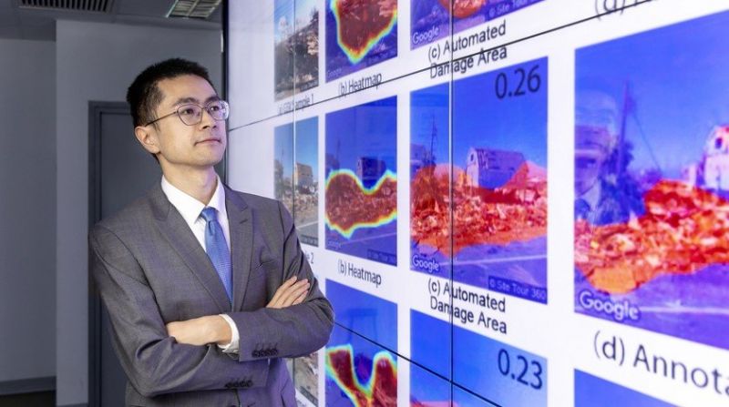
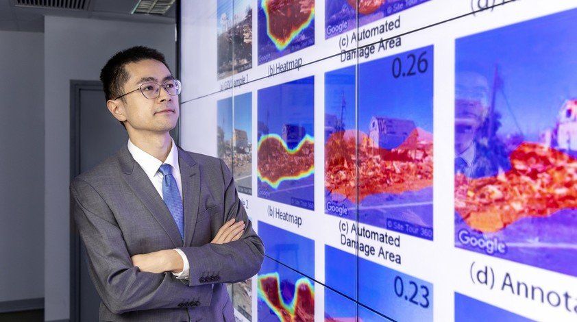
Dr Zhai has been researching the use of artificial intelligence to improve our understanding of individuals' perception of disasters and the damage they cause. The research team found that damage assessments based on Google Street View images can provide timely and accurate data on the ground. Such information is invaluable to humanitarian organisations and disaster management practitioners, as it allows them to devise recovery strategies.
The impact of the deadly storm and the local government's response to the disaster made a lasting impression on Dr. Zhai Wai
, who was then pursuing his postgraduate studies at the University of Florida, and he had just arrived in the state a few days before the hurricane hit.
Four years later, he is investigating how to improve disaster management. "Seeing firsthand how disasters such as hurricanes and flooding affect the people living in coastal regions, I believe that urban planners play an important role in helping governments develop strategies to respond to the disasters and improve social equity in the face of extreme weather events," says the Assistant Professor of the Department of Geography.
A human-centric approach
Assessing how people perceive risk and damage in the context of natural hazards is central to improving disaster preparedness and recovery. To that end, Dr Zhai has been researching the use of artificial intelligence (AI) to improve our understanding of individuals’ perception of disasters and the damage they cause.
In a study examining the use of Google Street View (GSV) images in damage assessment, Dr Zhai and his colleagues looked at how the human eye perceives the amount of damage present in GSV images. "Existing approaches, such as remote sensing imagery, typically use satellite imagery and measure the damage in an area at a distance, but this cannot reflect how people are actually interpreting the disaster situation. Our research took a more human-centric approach, and it reflects how individuals perceive disasters," says Dr Zhai.
The team applied a deep learning model to automate the process of evaluating post-disaster damage levels using GSV images, and they found that GSV-based damage assessments offer insights that remote sensing imagery cannot, such as recording damage to exterior walls, windows and doors. When the overall damage level is relatively low, a GSV-based damage assessment can provide timely and accurate data on the ground. Such information is invaluable to humanitarian organisations and disaster management practitioners, as it allows them to devise recovery strategies.
Assessing situational awareness through social media
According to Dr Zhai, another critical aspect of disaster management involves addressing the recovery needs of different neighbourhoods. In particular, a neighbourhood's situational awareness (SA), or their understanding of the situation in the field, helps disaster response agencies stabilise the risks and prevent further losses in disadvantaged communities, thereby improving equity in terms of disaster assistance and relief.
Although SA is hard to obtain during a disaster due to logistical and communication difficulties, Dr Zhai believes that many of these challenges can be solved with new technologies. "With the use of AI technology, we can analyse geotagged data on social media and learn how the users of the affected areas are responding to the disaster in real-time," he says. "When compared to the current approaches of conducting surveys and retrospective studies, the application of AI enables us to find out the attitudes and concerns of a much larger population."
In his research project
, Dr Zhai and his colleagues adopted machine learning-based natural language processing methods to conduct sentiment analysis on social media posts. He says, "This type of user-generated content can also be combined with the users' sociodemographic information, which could help us assess which neighbourhoods are more vulnerable in a disaster event. By understanding disaster SA from the perspective of social equity, the authorities can make faster and more accurate decisions on response efforts."
Building a disaster-resilient city
Having grown up in a small town in mainland China, Dr Zhai has always been fascinated by the development and functions of megacities, as well as how social equity can be improved through urban planning. After obtaining a master's degree in urban planning from Tsinghua University, he pursued both a master's degree in computer engineering and a PhD in urban and regional planning at the University of Florida.
"When I was carrying out research in urban planning, I found that there were some computer engineering techniques I needed to apply to my project, so I became determined to learn programming skills and new technologies in order to complete my research," he says. As he did not have any background in computer science at the time, it was his sheer determination and passion for research, as well as help from computer-savvy friends, that carried him through. "Learning computer engineering techniques was quite an interesting and fruitful experience in my career. It has been beneficial to my current research projects."
Having joined HKBU this year, Dr Zhai is particularly interested in working with researchers from both of the branches in geography: human geography and physical geography, as his research interests cover the study of urban planning as well as extreme weather events. He is also working on an interdisciplinary research collaboration with Dr Celine Song of the Department of Journalism, and their study focuses on disaster misinformation and corrections on social media.
While he believes that Hong Kong is well-prepared for typhoons and that it has effective emergency response plans in place, he says that the coastal city will be susceptible to the threat of rising sea levels in the future. He has been developing a research project on how rising sea levels influence property prices, which can provide insights into the impact of climate change on urban development. He says of his motivation for research, "I find research work very rewarding, as it can make a real contribution by helping decision-makers and disaster management practitioners develop improved response strategies and capabilities."
The Study of Coastal Hazards under Climate Change and Extreme Weather and Formulation of Improvement Measures - Feasibility Study (Coastal Hazards Study) has comprehensively reviewed the impacts of storm surges and waves on coastal low-lying or windy locations under extreme weather and climate change.
It has identified 26 coastal low-lying or windy residential areas with higher risks (details see diagram below) for formulation of improvement works and management measures to safeguard public safety.
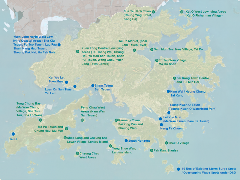
The improvement works comprise various protective and adaptive options, which may include constructing or raising wave walls along the coastline, installing flood barriers at suitable places behind the coastline to cut off water pathways towards inland areas, and/or installing demountable flood barriers at building frontages. Management measures will involve the formulation of action plans on early alert systems and emergency preparedness. The final report and executive summary of the Coastal Hazards Study are as below.
*This article originates from Civil Engineering and Development Department (CEDD).
https://www.cedd.gov.hk/eng/our-projects/project-reports/index-id-24.html
[This article is only available in Chinese.]
[This article is only available in Chinese.]
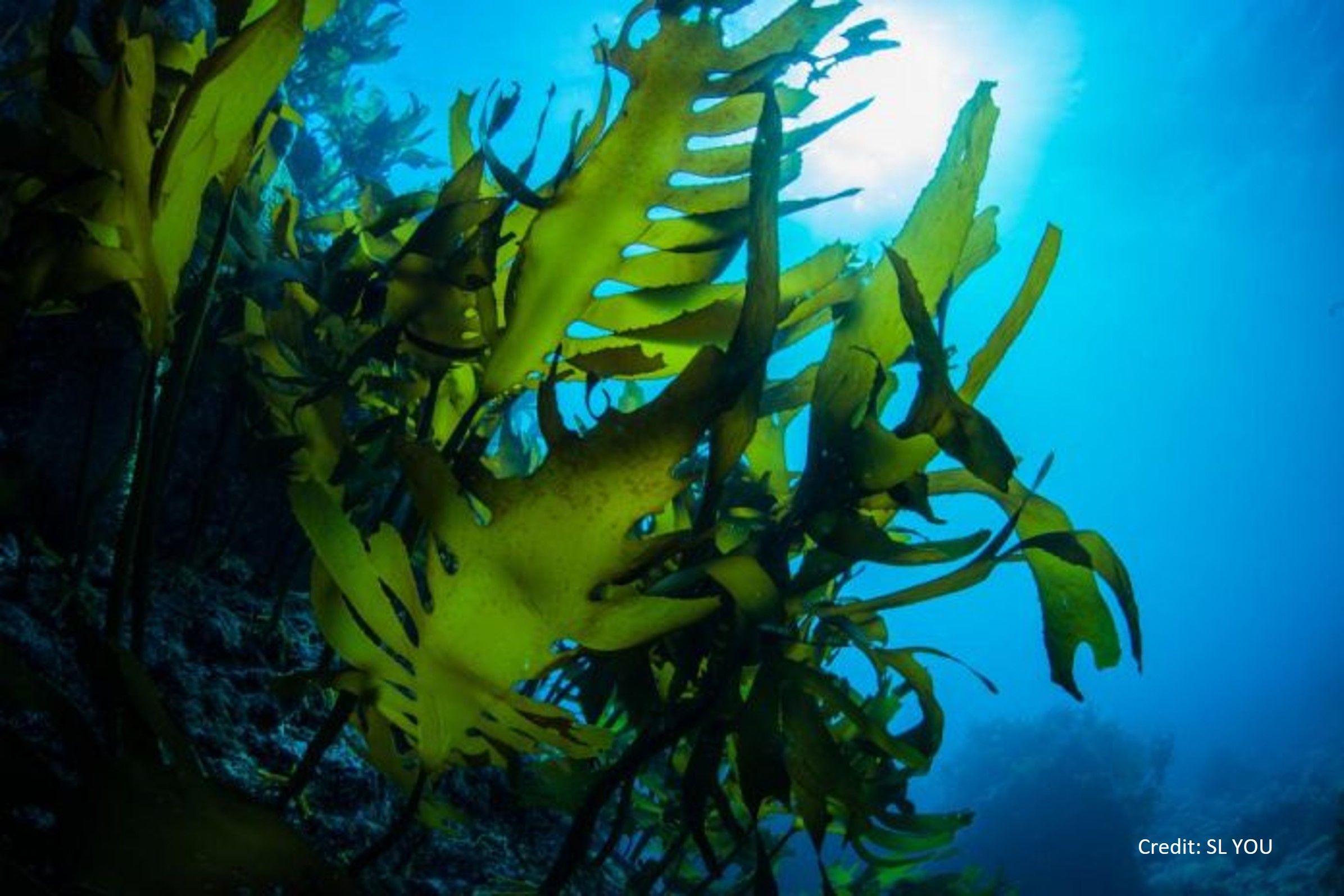
海洋中的微型藻類不僅會產生獨特的芬芳氣味,這些揮發性分子更會促進大氣內雲的形成,從而影響地球氣候。
海水本身沒有什麼氣味,但是海風的確充滿很多來自海中生物的「鮮氣」。海洋漂浮着微小的浮游植物,它們的細胞內有一種稱為「二甲基巰基丙酸」的硫化合物,英文簡稱DMSP。當它們被浮游動物捕食時,浮游植物細胞內的DMSP便會釋放到水中,成為細菌的食物,而在過程中DMSP被分解成更細小的揮發性硫化合物「二甲硫醚」分子(英文簡稱DMS),也就是海風和一些海鮮氣味的主要物質,類似打開紫菜零食包裝時嗅到的香味。
有時在海邊嗅到的氣味不一定令人心曠神怡。
由於海洋生物體內的蛋白質被分解時也會產生DMS,所以通常是潮退時分被浪潮沖上岸的海藻和海洋生物的屍體會釋出DMS,或是當水中的微型藻類生長得太活躍,就很有機會嗅到強烈怪怪的氣味。其實不論是清香的紫菜,還是鹹腥的死魚,這些我們在海邊感受到的特殊氣味都與浮游生物有關。很低濃度的DMS一般會給人一種舒服的海洋氣味,但當DMS濃度稍高一點便會令人難受。
海洋的氣味對各種海洋動物都很重要,例如海龜以至鯨鯊,牠們靠探測DMS來追踪獵物,因為DMS的氣味代表著那裏富含小魚視作美食的浮游生物,而小魚又會被大魚吃,浮游植物就這樣支撐着海洋的食物網。除了尋找食物外,海鷗和一些海中動物亦要靠DMS的氣味來判斷歸巢的方向。
除了以上功能,DMS還默默影響著海洋上空雲的形成,從而影響地球的氣候。硫在地球中含量豐富,對生命亦至關重要。而DMS是地球上生物產生得最多的一種有機硫化合物;由於它是一種揮發性氣體,所以會迅速進入大氣,科學家估算每年約有3億噸DMS從海洋中釋放出來。DMS在空氣中進行一連串化學反應,產生二氧化硫和其他硫酸鹽等化合物,並形成直徑小於1微米的氣霧(又稱氣溶膠)。這些氣霧顆粒擔當「造雲粒子」的角色,在大氣中作為凝結核讓水蒸氣凝結並聚集成雲。
天上的雲不僅為大地帶來雨水,它對氣候的影響亦非常巨大。比如,像棉花糖般蓬鬆的白雲因著反照率效應能將陽光反射回太空,有助保持地球表面涼爽。同時,厚雲又會在夜間吸收從地球表面釋放出來的熱量,並反射回地球。換句話說,DMS透過雲的形成,充當地球的恆溫器,防止地球表面過熱或過冷。浮游植物大量繁殖會產生更多的DMS,因而大氣中便有更多的雲。除此之外,浮游植物也可以藉着光合作用,把大氣中的二氧化碳去除,減少大氣中的溫室氣體,亦有助地球降溫。
除了海裏的浮游植物外,陸上的沼澤地和沿海沉積物中的細菌亦會產生DMSP。科學家估計,每1克的鹽沼沉積物中,有多達1億個能夠產生DMSP的細菌。科學界對於硫的「生物地質化學循環」尚未了解得很清楚,透過持續研究DMS如何影響雲的大小和密度,可讓我們了解更多氣候調節的過程。
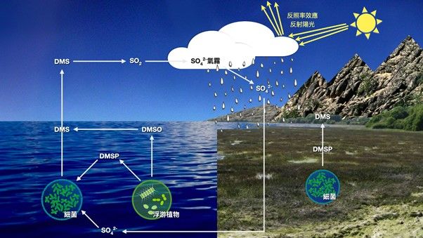
圖:硫循環涉及細菌和浮游植物的生物途徑
SO42-:硫酸根離子
DMSP:二甲基巰基丙酸
DMSO:二甲基亞碸
DMS:二甲硫醚
SO2 :二氧化硫
麥嘉慧,科普作家
博客: https://www.drkarenmak.com/
Patron: https://www.patreon.com/drkarenmak
2021

[This article is only available in Chinese.]
[This article is only available in Chinese.]
麥嘉慧,科學人
狗常被稱作人類最好的朋友。除了作為日夜陪伴的寵物、家門的守護員、獵人或牧人的助手,以及盲人的導航員外,牠更可以在災難現場中擔當搜索被困傷者的重任。
在大規模災難發生後,例如在倒塌的建築物或山泥傾瀉的瓦礫下,確定現場是否有人被困並將他們救出,絕對是分秒必爭的任務。但是,由於環境惡劣,空間狹窄,救援人員未必能深入瓦礫,此時搜索犬就可以大展身手!搜索犬可以用牠驚人的嗅覺,探測人體釋放的氣味,幫助尋找並定位被困的人,讓救援人員用安全方法將他們救出。

墨西哥著名搜救犬 Frida服役9年間拯救超過50人 (圖片來源: 轉角國際)
訓練有素的搜索犬既忠心又勇敢,可是與救援人員一樣,在執行任務後一段時間,便需要休息。被困者可能受傷,也可能受到壓迫而難以呼吸,因此在瓦礫時間越久,生存的機會便會越低。為了把握黃金救援時間,科學家發明了一個稱為「電子鼻」的儀器,它能夠如搜索犬的鼻子一樣靈敏,分擔搜索犬的工作。
電子鼻由數個微型感應器組成,內部有三塊摻雜矽或鈦的納米構造半導體薄膜,負責檢測代表生命跡象的揮發性化學物質,包括丙酮、氨(俗稱阿摩尼亞)和異戊二烯(isoprene)。儀器內同時有兩個感應器,用來探測二氧化碳和水蒸氣。這些物質會在我們呼吸時,或是從皮膚中釋放出來。歐洲的研究團隊自數年前開始研發這一種電子鼻,邀請志願者模擬被困在狹小空間,並利用電子鼻探測他們釋出的極微量化學物質。確認物質接觸到感應器後便會發生化學反應並產生電子信號,通知使用者。
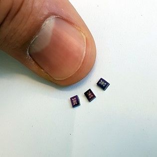
微型感應器 (圖片來源: New Atlas)
事實上,以往也有類似電子鼻的設備,不過儀器體積龐大,不便救援人員攜帶;加上當時技術還未成熟,能檢測目標化合物的靈敏度低,而製造成本也頗高。最新開發的電子鼻製造成本低廉,且體積輕巧,可以設計成手提裝置,甚至靠無人機攜帶便可到災難現場進行搜索,協助在災場內更隱蔽和危險的角落作探測。新發明將有望進一步幫助救援人員更快速準確地確定受災範圍,適當分配人力和資源作出搶救。
那麼我們「最好的朋友」很快就會失業了嗎?目前來說言之尚早。更多的電子鼻測試和調校仍然在進行,以提高其可靠性,加上在使用上的一些局限(例如讀數不夠穩定,環境中可能出現訊號干擾等)。因此,我們仍要依靠搜索犬的幫忙,而且救援人員的勇氣和專業精神,更是電子鼻無法取代的。
電子鼻相關研究在近年迅速發展,運用相同概念,科學家可以發明各種電子鼻去應付其他工作犬的任務:偵查人口販賣、檢測爆炸品和毒品等,而且有效檢測爆炸品亦有助預防災難發生。此外,樓宇倒塌後的瓦礫堆不時會發生爆炸,所以電子鼻的應用亦將有助減低此類災場環境的危險性。除了搜救生還者,只要稍稍調整電子鼻內的感應晶片,便可以檢測人類屍體散發出的獨特氣體,幫助判斷受災被困的人是否還活著。
對於受災甚至死難者的家屬來說,電子鼻可以幫助提供更準確的被困者資訊,使親屬免於因漫長等待而產生焦慮,縮短因為不確定而帶來的不安,即使最後確認不幸遇難,在某程度上亦能縮短他們的情緒復原時間、盡快渡過哀傷。
麥嘉慧,科學人
Reference:
Sniffing Entrapped Humans with Sensor Arrays
Anal. Chem. 2018, 90, 4940−4945 DOI: 10.1021/acs.analchem.8b00237


