You are here
Managing disasters with artificial intelligence
Managing disasters with artificial intelligence
*This article originates from Hong Kong Baptist University
4 January 2022
Peaking with one-minute sustained winds of 285 km/h, the Category 5 Hurricane Irma ripped through the Caribbean islands and the southeast of the United States in September 2017. After the storm made landfall in Florida, it caused widespread destruction along its path, tearing off roofs, flooding coastal cities, and causing at least 84 fatalities in the state.
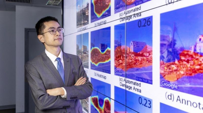
Dr Zhai has been researching the use of artificial intelligence to improve our understanding of individuals' perception of disasters and the damage they cause. The research team found that damage assessments based on Google Street View images can provide timely and accurate data on the ground. Such information is invaluable to humanitarian organisations and disaster management practitioners, as it allows them to devise recovery strategies.
The impact of the deadly storm and the local government's response to the disaster made a lasting impression on Dr. Zhai Wai
, who was then pursuing his postgraduate studies at the University of Florida, and he had just arrived in the state a few days before the hurricane hit.
Four years later, he is investigating how to improve disaster management. "Seeing firsthand how disasters such as hurricanes and flooding affect the people living in coastal regions, I believe that urban planners play an important role in helping governments develop strategies to respond to the disasters and improve social equity in the face of extreme weather events," says the Assistant Professor of the .
A human-centric approach
Assessing how people perceive risk and damage in the context of natural hazards is central to improving disaster preparedness and recovery. To that end, Dr Zhai has been researching the use of artificial intelligence (AI) to improve our understanding of individuals’ perception of disasters and the damage they cause.
In a study examining the use of Google Street View (GSV) images in damage assessment, Dr Zhai and his colleagues looked at how the human eye perceives the amount of damage present in GSV images. "Existing approaches, such as remote sensing imagery, typically use satellite imagery and measure the damage in an area at a distance, but this cannot reflect how people are actually interpreting the disaster situation. Our research took a more human-centric approach, and it reflects how individuals perceive disasters," says Dr Zhai.
The team applied a deep learning model to automate the process of evaluating post-disaster damage levels using GSV images, and they found that GSV-based damage assessments offer insights that remote sensing imagery cannot, such as recording damage to exterior walls, windows and doors. When the overall damage level is relatively low, a GSV-based damage assessment can provide timely and accurate data on the ground. Such information is invaluable to humanitarian organisations and disaster management practitioners, as it allows them to devise recovery strategies.
Assessing situational awareness through social media
According to Dr Zhai, another critical aspect of disaster management involves addressing the recovery needs of different neighbourhoods. In particular, a neighbourhood's situational awareness (SA), or their understanding of the situation in the field, helps disaster response agencies stabilise the risks and prevent further losses in disadvantaged communities, thereby improving equity in terms of disaster assistance and relief.
Although SA is hard to obtain during a disaster due to logistical and communication difficulties, Dr Zhai believes that many of these challenges can be solved with new technologies. "With the use of AI technology, we can analyse geotagged data on social media and learn how the users of the affected areas are responding to the disaster in real-time," he says. "When compared to the current approaches of conducting surveys and retrospective studies, the application of AI enables us to find out the attitudes and concerns of a much larger population."
In his research project
, Dr Zhai and his colleagues adopted machine learning-based natural language processing methods to conduct sentiment analysis on social media posts. He says, "This type of user-generated content can also be combined with the users' sociodemographic information, which could help us assess which neighbourhoods are more vulnerable in a disaster event. By understanding disaster SA from the perspective of social equity, the authorities can make faster and more accurate decisions on response efforts."
Building a disaster-resilient city
Having grown up in a small town in mainland China, Dr Zhai has always been fascinated by the development and functions of megacities, as well as how social equity can be improved through urban planning. After obtaining a master's degree in urban planning from Tsinghua University, he pursued both a master's degree in computer engineering and a PhD in urban and regional planning at the University of Florida.
"When I was carrying out research in urban planning, I found that there were some computer engineering techniques I needed to apply to my project, so I became determined to learn programming skills and new technologies in order to complete my research," he says. As he did not have any background in computer science at the time, it was his sheer determination and passion for research, as well as help from computer-savvy friends, that carried him through. "Learning computer engineering techniques was quite an interesting and fruitful experience in my career. It has been beneficial to my current research projects."
Having joined HKBU this year, Dr Zhai is particularly interested in working with researchers from both of the branches in geography: human geography and physical geography, as his research interests cover the study of urban planning as well as extreme weather events. He is also working on an interdisciplinary research collaboration with Dr Celine Song of the Department of Journalism, and their study focuses on disaster misinformation and corrections on social media.
While he believes that Hong Kong is well-prepared for typhoons and that it has effective emergency response plans in place, he says that the coastal city will be susceptible to the threat of rising sea levels in the future. He has been developing a research project on how rising sea levels influence property prices, which can provide insights into the impact of climate change on urban development. He says of his motivation for research, "I find research work very rewarding, as it can make a real contribution by helping decision-makers and disaster management practitioners develop improved response strategies and capabilities."